 California’s groundwater is being rapidly depleted because cities and farms extract more than is replenished naturally, compacting local aquifers and decreasing supply in some places in the Central Valley.
And, it turns out, levees placed along rivers in the late 1800s and early 1900s to protect farms and cities from floods are actually hurting farmers’ and residents’ ability to access water.
But UC Merced Professor Josh Viers and colleagues found an engineering solution to improve some of the state’s groundwater supplies and fisheries — moving river levees to make room for flood waters.
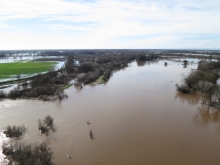
Preliminary results from the research project, now in its fourth year, indicate that the brief February storm resulted in 100 to 300 acre-feet of recharge to the 500-acre floodplain. That is roughly three times the amount of recharge that would occur through irrigation.
And because the levees have been moved, that amount of recharge will now happen three times more often per year, on average, providing a potential 1,000 acre-feet more local water storage.
This is welcome news as the state works to shore up levees in flood-prone areas. Gov. Jerry Brown last week signed drought-emergency legislation that also advanced $660 million of Proposition 1E (2006) money for flood protection, including construction of “setback levees” — those that make room for floodwaters and groundwater recharge.
 “What people forget is that the Central Valley was once a swamp,” Viers said. “Before we built dams in the Sierras and channelized the rivers downstream, stream runoff from rain and snowmelt would spread out onto adjacent floodplains and recharge local aquifers. But prolonged drought and lack of floodplains have limited groundwater recharge throughout the region.”
As opportunities for recharge have decreased – exacerbated by the severe drought – Californians’ dependence on groundwater has increased, creating an unsustainable situation for local communities relying on groundwater for drinking water and irrigation.
Viers, the co-director of the new UC Water Security and Sustainability Research Initiative (WASSRI), leads other UC Merced faculty members and researchers from UC Davis, Washington State University and the Department of Fish and Wildlife on a research project aimed to promote multiple benefits from engineered levee setbacks. Viers is also the director of the campus's branch of Center for Information Technology Research in the Interest of Society (CITRIS) and an affiliate with the Sierra Nevada Research Institute (SNRI).
The project is being incorporated into WASSRI to set up sensor-system monitoring and devise plans for groundwater sustainability and land management throughout the Central Valley and Central Coast.
As the state struggles with a severe and lengthy drought and begins to sort out plans for the future, the data and modeling provided by researchers like Viers is more vital than ever.
Setback levees are expensive. A 3,400-foot-long structure and associated riparian restoration planned along the lower Feather River in Sutter County is estimated at $20 million. But such projects can bring multiple long-term benefits.
Working near Lodi on the Cosumnes River— the Sierra’s only river without a large dam — Viers and his colleagues can study what happens to rivers, floodplains and groundwater under natural conditions. The river floods often enough that there has been no development on the nearby floodplain, so it’s the perfect place to examine groundwater recharge through a series of monitored wells.
“We see that flooding does have a net benefit, even in a drought year,” Viers said. “In wetter years, it also improves the salmon fishery, because the floodplain is like an incubator. It provides the right food and water temperature for juvenile salmon. Spending time there helps them grow larger faster, gives them places to hide from predators so there are more of them, and improves their chances of survival once they reach the ocean.”
The project takes a lot of time and money, from hiring bulldozers to move the levees to the environmental permitting required to do so. The researchers removed levees adjacent to the river that were in risk of being overtopped, but contained flood waters across an 500-acre floodplain with levees set far back from the river.
So far, the researchers have found that moving the Cosumnes’ levees has actually reduced flood risks for neighbors and has allowed row-crop agriculture to persist on portions of the floodplain, as well as recharging the local aquifer.
Other UC Merced researchers, like Professors YangQuan Chen and Marilyn Fogel, are collaborating on the project to gather data using unmanned aerial vehicles and through stable isotope analysis to monitor the floodplain’s hydrology. The information feeds into regional models for the Central Valley, allowing land and resource managers to turn data into decisions.
“We’re measuring the whole system — the groundwater, the surface water and its constituents,” Viers said. “You can’t manage what you don’t measure. So scientists from the UC are helping build a strategic base of water data and knowledge to help California and the nation achieve a water-secure future.”